
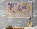


Description
World map in French with political borders.
Discover the political borders that separate countries from each other, thanks to this world planisphere in French , you will also find a lot of information, such as the names of countries, capitals... In addition, Thanks to these magnificent colors, it will also be an ideal decorative object for your interior
◽ GEOGRAPHICAL DATA ◽
- - Names of countries
- - Names of capitals and many major cities
- - Names of the largest rivers
- - Names of the largest lakes
- - Names of the largest seas and oceans
- - Highest peak
- - Deepest oceanic trench
◽ SUPPORT: PLEXIGLAS ◽
- - Printing technique: 5/0 day and night
- - Three layers are applied to the material for optimal results
- - With a matte finish, ideal for bright rooms
- - Comes with a mounting kit, which will give the card a weightless effect
- - Lightweight, it can also be hung with double-sided tape
- - Processing + Printing + Delivery = 6 to 7 working days
◽ ADDITIONAL INFORMATION ◽
- - Language: French
- - High Definition Image
- - Well-defined details and vibrant colors
- - Customizable (Add the city or village of your choice)
- - Brand: Modern-Map


