


Description
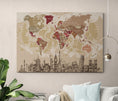
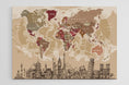
Large world map with country names and political boundaries.
From the European continent to that of America via the Atlantic Ocean, the surface of the earth will no longer hold any secrets for you, thanks to this large world map . Moreover, with its decorative side, this wall map can be perfectly hung above the marital bed or in your living room, for your whole family to enjoy!
◽ GEOGRAPHIC DATA ◽
- - Names of countries
- - Names of capitals and many major cities
- - Names of the largest rivers
- - Names of the largest lakes
- - Names of the largest seas and oceans
- - Highest peak
- - Deepest oceanic trench
◽ CUSTOMIZATIONS ◽
- - Adding the city or village of your choice
- - Addition of a QR code, integrated into the compass rose, allowing access to the Worldometers site
◽ SUPPORT: PLEXIGLAS ◽
- - Printing technique: 5/0 day and night
- - Three layers are applied to the material for optimal results
- - Matte finish, ideal for bright rooms
- - Comes with a mounting kit, which will give the card a weightless effect
- - Lightweight, it can also be hung with double-sided tape
- - Processing + Printing + Delivery = 6 to 7 working days
◽ ADDITIONAL INFORMATION ◽
- - Language: French
- - High Definition Image
- - Well-defined details and vibrant colors
- - Brand: Modern-Map


