


Description
School world map with lots of geographic information.
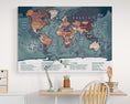
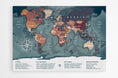
This school world map doesn't just display countries: it tells the story of the planet through its details. Each country, capital, and major city is precisely marked, while the seas and oceans stretch out like vast blue paths connecting the continents. Thanks to its Van der Grinten projection , the Earth takes on a harmonious shape, where everything is in its place, from the highest peak to the deepest abysses.
The legend transforms this map into a veritable wall atlas . It reveals the surface area of the continents and oceans, the mass of the globe, the circumference of the equator, but also fascinating data such as the world population, life expectancy, the number of languages spoken, religions, and even global GDP. It is a gateway to a broader understanding of the world, enriched by a link to Worldometer to follow global statistics live.
Available as a large format poster or wall chart , this map naturally finds its place in a bedroom, an office or a living room.
 GEOGRAPHIC DATA
- Van der Grinten screening
- Names of countries
- Names of capitals and many major cities
- Names of the largest rivers
- Names of the largest lakes
- Names of the largest seas and oceans
- Highest peak in the world
- Deepest oceanic trench on Earth
![]() IN LEGEND
IN LEGEND
- - Surface area and mass of the Earth
- - Ocean area
- - Land area
- - Circumference of the equator
- - Area and population of the 6 continents
- - Surface area and volume of the 5 oceans
- - Number of human beings on the globe
- - Life expectancy
- - Number of languages spoken
- - Number of religions
- - World GDP
- - Access to the Worldometer website
![]() SUPPORT CHARACTERISTICS
SUPPORT CHARACTERISTICS
— PREMIUM POSTER
- Paper : 250 g/m² Matte coated
- Image : High Definition (300 Dpi)
- Print on demand, in Germany, in two copies.
— MAGNETIC (0.6 mm flexible support)
- Durability: Made from a tear-resistant and waterproof material, this material is designed to withstand repeated handling.
- Magnetic surface: Its surface allows you to attach magnets to mark destinations visited or upcoming adventures, as well as to hang your travel photos and postcards. A fun and interactive way to plan and share your experiences.
- Includes : Double-sided tape to hang your world map, as well as 10 gold-colored and 10 chrome-colored neodymium magnets ( shipped separately )
- Image : High Definition (300 Dpi)
- Print on demand, in France.
— BRUSHED ALU-DIBOND (rigid support)
- Brighten your walls with the subtle reflection of brushed metal. A world map that combines aesthetics and modernity.
- Printing technique : thanks to a printing called 5/0 four-color + 200% white, every detail is meticulously highlighted, offering magnificent visual quality.
- Optimal rendering : the application of three layers on the material guarantees an optimal result and remarkable sharpness, thus ensuring that each element stands out precisely.
- Matte finish and vibrant colors : The matte finish, ideal for bright rooms, gives a timeless elegance, while the vibrant colors attract the eye and add a modern touch to your decor.
- Weightless effect : Supplied with a mounting kit, the map appears to float on your wall, adding an extra dimension to your interior decoration.
- Print on demand, in Germany.
![]() ADDITIONAL INFORMATION
ADDITIONAL INFORMATION
- Processing + Printing + Delivery ≃ 4 to 6 Working Days