


Description
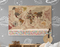
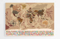
XXL world map with political borders and country names.
Do you want to improve your geography skills? Then this XXL multi-colored world map will be perfect for learning the names of the seas, oceans, and the world's largest cities. Thanks to its decorative design, it will also find a place of choice in a modern kitchen or living room above a fireplace!
◽ GEOGRAPHIC DATA ◽
- - Names of countries
- - Names of capitals and many major cities
- - Names of the largest rivers
- - Names of the largest lakes
- - Names of the largest seas and oceans
- - Highest peak
- - Deepest oceanic trench
- - Flags
◽ CUSTOMIZATIONS ◽
- - Adding the city or village of your choice
- - Addition of a QR code, integrated into the compass rose, allowing access to the Worldometers site
◽ SUPPORT: PLEXIGLAS ◽
- - Printing technique: 5/0 day and night
- - Three layers are applied to the material for optimal results
- - Matte finish, ideal for bright rooms
- - Comes with a mounting kit, which will give the card a weightless effect
- - Lightweight, it can also be hung with double-sided tape
- - Processing + Printing + Delivery = 6 to 7 working days
◽ ADDITIONAL INFORMATION ◽
- - Language: French
- - High Definition Image
- - Well-defined details and vibrant colors
- - Brand: Modern-Map


