


Description
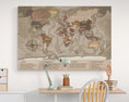
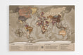
School world map with countries and cities of the world.
This school world map is a comprehensive educational tool that covers the essentials of world geography. In addition to clearly depicting countries, capitals, and many major cities, it highlights major rivers, lakes, seas, and oceans. With its Van der Grinten projection , it offers a balanced view of the globe, while also incorporating unique information such as the highest point on Earth (Mount Everest) and the Mariana Trench, the deepest trench in the world.
Its detailed key further enhances learning by showing the surface area of land and oceans, the mass of the Earth, the circumference of the equator, and the distribution of the population across the six continents. It also provides valuable data on life expectancy, the number of languages spoken, religions, global GDP, and even direct access to the Worldometer website to track statistics updated in real time.
Available as a poster or wall chart , this world map is both decorative and educational. Perfect for a classroom, library, or even a living room at home, it adorns your walls while making geography lively and accessible to all.
![]() GEOGRAPHIC DATA
GEOGRAPHIC DATA
- Van der Grinten screening
- Names of countries
- Names of capitals and many major cities
- Names of the largest rivers
- Names of the largest lakes
- Names of the largest seas and oceans
- Highest peak in the world
- Deepest oceanic trench on Earth
![]() IN LEGEND
IN LEGEND
- - Surface area and mass of the Earth
- - Ocean area
- - Land area
- - Circumference of the equator
- - Area and population of the 6 continents
- - Surface area and volume of the 5 oceans
- - Number of human beings on the globe
- - Life expectancy
- - Number of languages spoken
- - Number of religions
- - World GDP
- - Access to the Worldometer website
![]() SUPPORT CHARACTERISTICS
SUPPORT CHARACTERISTICS
— PREMIUM POSTER
- Paper : 250 g/m² Matte coated
- Image : High Definition (300 Dpi)
- Print on demand, in Germany, in two copies.
— MAGNETIC (0.6 mm flexible support)
- Durability: Made from a tear-resistant and waterproof material, this material is designed to withstand repeated handling.
- Magnetic surface: Its surface allows you to attach magnets to mark destinations visited or upcoming adventures, as well as to hang your travel photos. A fun and interactive way to plan and share your experiences.
- Includes : Double-sided tape to hang your world map, as well as 10 gold-colored and 10 chrome-colored neodymium magnets ( shipped separately )
- Image : High Definition (300 Dpi)
- Print on demand, in France.
— BRUSHED ALU-DIBOND (rigid support)
- Brighten your walls with the subtle reflection of brushed metal. A world map that combines aesthetics and modernity.
- Printing technique : thanks to a printing called 5/0 four-color + 200% white, every detail is meticulously highlighted, offering magnificent visual quality.
- Optimal rendering : the application of three layers on the material guarantees an optimal result and remarkable sharpness, thus ensuring that each element stands out precisely.
- Matte finish and vibrant colors : The matte finish, ideal for bright rooms, gives a timeless elegance, while the vibrant colors attract the eye and add a modern touch to your decor.
- Weightless effect : Supplied with a mounting kit, the map appears to float on your wall, adding an extra dimension to your interior decoration.
- Print on demand, in Germany.
![]() ADDITIONAL INFORMATION
ADDITIONAL INFORMATION
- Processing + Printing + Delivery ≃ 4 to 6 Working Days


