
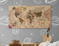
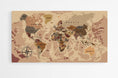


Description
World map of countries in French on a wall chart.
This world map of countries in French will be very popular with children and the whole family, for its originality and its geographical data, written entirely in French, printed on Plexiglas, it will hang on the wall of your house or apartment with great simplicity.
◽ GEOGRAPHICAL DATA ◽
- - Names of countries
- - Names of capitals and many major cities
- - Names of the largest rivers
- - Names of the largest lakes
- - Names of the largest seas and oceans
- - Highest peak
- - Deepest oceanic trench
◽ CUSTOMIZATIONS ◽
- - Adding the city or village of your choice
- - Addition of a QR code, integrated into the compass rose, allowing access to the Worldometers site
◽ SUPPORT: PLEXIGLAS ◽
- - Printing technique: 5/0 day and night
- - Three layers are applied to the material for optimal results
- - Matte finish, ideal for bright rooms
- - Comes with a mounting kit, which will give the card a weightless effect
- - Lightweight, it can also be hung with double-sided tape
- - Processing + Printing + Delivery = 6 to 7 working days
◽ ADDITIONAL INFORMATION ◽
- - Language: French
- - High Definition Image
- - Well-defined details and vibrant colors
- - Brand: Modern-Map


