


Description
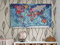
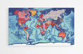
Large geographical map of the world with countries and cities.
Dive into exploring the globe with this large world map . Countries are represented in distinct colors, allowing for easy identification of each region, while numerous cities and geographic data are included for accurate and informative reading.
Ideal for study, learning or simply decoration , this world map will quickly become an essential support for the whole family. From north to south and from east to west, discover the continents and enrich your knowledge of geography!
 GEOGRAPHIC DATA
- Van der Grinten screening
- Names of countries
- Names of capitals and many major cities
- Names of the largest rivers
- Names of the largest lakes
- Names of the largest seas and oceans
- Highest peak on the globe
- Deepest oceanic trench
![]() — PERSONALIZATION (QR code added in the compass rose)
— PERSONALIZATION (QR code added in the compass rose)
-
QR CODE #1 : This can be added to give you direct access to the Worldometers website. There you will find a wealth of real-time information on the world's population and other fascinating data.
-
QR CODE N° 2 : the second QR code is fully customizable : I associate it with the link of your choice (photo album, personal website, travel blog, etc.) so that your card becomes an interactive and unique support.
- ADD : the name of your village , your town or a symbolic place to create a wall map in your image.
![]() — CHARACTERISTICS OF THE SUPPORTS
— CHARACTERISTICS OF THE SUPPORTS
📜 CLASSIC POSTER
- Support: 200 g/m² matte coated paper PEFC certified (paper from sustainably managed forests)
- Printed in high definition, on demand, in France, by a Label Vert certified printer
🧲 MAGNETIC POSTER
- Durability: Made from a tear-resistant and waterproof material, this material is designed to withstand repeated handling
- Magnetic surface: its surface allows you to attach the included magnets to mark destinations visited or upcoming adventures, as well as to hang your travel photos or postcards. A fun and interactive way to plan and share your experiences
- Included : double-sided tape for hanging the card + 20 neodymium magnets (10 gold, 10 chrome) (shipped separately)
- Printed in high definition, on demand, in France
🔹 PLEXIGLAS
- Printing technique : thanks to a printing called 5/0 four-color + 200% white carried out in three layers, each element is sublimated with precision, for an optimal visual rendering and a card that immediately catches the eye.
- Brilliance and depth of colors : the plexiglass surface provides a shiny effect that intensifies contrasts and gives an impression of depth.
- Included : Supplied with a mounting kit, the map appears to float on your wall, adding an extra dimension to your interior decoration.
-
Printed on demand, in Germany
![]() — ADDITIONAL INFORMATION
— ADDITIONAL INFORMATION
- Format: 130x76 cm
- Available language: French or English
- Processing, printing and delivery times: 5 to 6 working days


